Christopher Moriarty leaves Dublin to follow flow of River Slaney into Wexford.
In prehistoric times, the Rivers Slaney and Liffey fought for supremacy – but they settled down some thousands of years ago and now go their own sweet ways, although nearly meeting each other in wilder parts of West Wicklow. This trip down Slaney makes a delightful day’s excursion from Dublin, or perhaps a diversion from the main road for visitors making their way to the County Wexford ferryport of Rosslare.
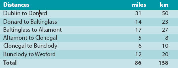
It begins by following Liffey Valley from Dublin's fair city, heading for Blessington along the N81 but avoiding all temptations to stop at such wonderful places as the stately home of Russborough or to plunge into the mountains and valleys of infant Liffey. To find headwaters of Slaney we follow the road south from Blessington for 11 miles (18 km) and, at Old Tollhouse pub, take the left turn for Donard.
In the tiny village of that name, with its well-kept green and a stone with a few letters carved in ancient Irish ogham script, turn left and immediately right where signpost says Military Road. This road was built after the great republican Rising of 1798 to facilitate the hunt for defeated rebels. It makes its narrow way through hills and woodland south-eastwards for four miles (6.5 km) and a crossroads in woods. The left turn is little more than a car-park and the site of a really good ogham stone.
This is the heart of the Glen of Imaal, enclosed on three sides by some of Wicklow’s most lofty mountains. The right turn leads downhill to our first encounter with River Slaney, which we cross by an old stone bridge. The road goes back towards west along south side of Glen, passing through crossroads village of Knockanarrigan, centred on a stolid granite-built post office, and then, just a little way after a school safety sign, a small car park allows a visit to stone circle of Castleruddery.
 5
5
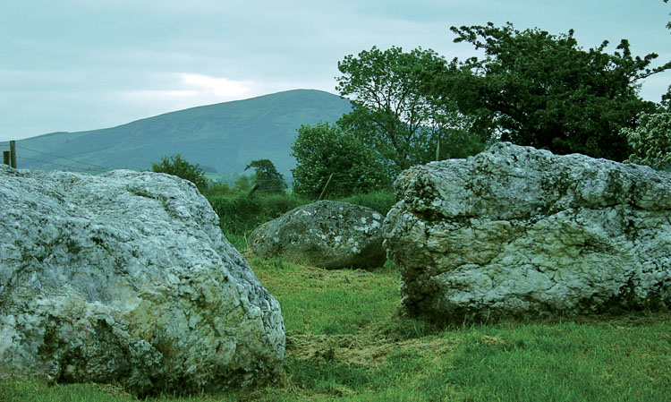
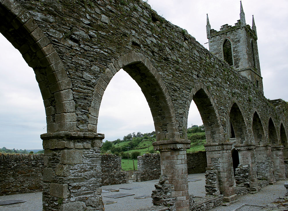
A helpful notice on site tells that this is an extremely rare sort of monument and, with a date of about 3,500 years before our time, a millennium and a half older than ordinary stone circles. A pair of massive blocks of quartz mark the entrance to what was once a great gathering ground for cattle barons of remote past. A mile farther on you meet the road to Baltinglass and turn left to follow Slaney to where the tower and ruined arches of an ancient Cistercian abbey overlook a calm stretch of river, created long ago by the building of a milldam.
In the village, turn left at the crossroads and immediately left again along a narrow lane. Founded in 1148, the long-abandoned abbey was so successful in its early years that it sent out groups of its monks to establish ‘daughter-houses’ in many parts of Ireland. What remains of its original stonework is of particular architectural interest because it has features both of old Irish Romanesque and innovative continental Gothic styles.
Back in the village, turn left and follow the main road for a mile, then take a rather unobtrusive road to the right to continue down the riverside to Rathvilly, a pleasant village with a particularly pleasing development of stone-built laborer’s cottages on right. Turn left to follow the main road through the hilly town of Tullow, where you begin to look out for signposts for Altamont. Centuries of love and hard work have gone into fabulous gardens there. You enter by way of beautiful parkland with shady trees. An old house, covered in creeper, stands on the brow of a steep hill and garden entrance is beside it.
At bottom of the hill, Slaney flows slowly by, hidden from outside world by woodland. About halfway down the slope is a lake created in the 19th century to provide work, pay, and food for survivors of Great Famine. Between house and lake is a beautifully-tended formal garden. Beyond the lake, a stream flows amongst great rocks in a woodland setting, wild in parts, but planted with many exotic shrubs and full of hidden paths and mystery.
When you leave Altamont, you might be tempted to cross the main road and get something to eat at delightful Forge restaurant. Our route takes a left turn at crossroads and heads for Clonegal, perhaps most delightful of all villages that we pass through. Its wide streets and neat houses wander up and down steep hills. In the center are two well-loved and tended gardens, each with objects well worth stopping to look at. There is a sculptured goat, constructed from wire mesh, in one. In other a great iron cauldron is preserved: it was used to make soup to feed starving people in Famine.
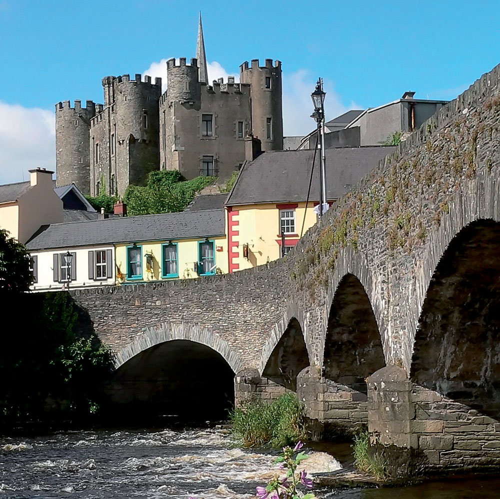
The Slaney runs by at bottom of the hill. Just before the bridge, on right, are gardens and parkland that surround Huntington Castle. Approached by a magnificent avenue of lime trees, this splendid building has dominated scene since 1625 and stands on site of an even older fortress, commanding crossing of river. A comfortable family home for three and a half centuries, its rooms contain a wonderful collection of trophies, works of art and fine furniture, to say nothing of an Egyptian temple instituted in 1976. Tea and guided tours are on offer from June through August.
Signposts from Clonegal lead you to Bunclody and then to Enniscorthy. The road after Bunclody runs beside Slaney where it flows between green watermeadows, backed by woodland. Enniscorthy, where the river meets tide and which once was an inland seaport, is our final destination. The road beyond it, along the tidal river, takes you to Ferrycarrig and town of Wexford. The Slaney at Enniscorthy goes through a narrow defile – meaning in practical terms that buildings and roads climb and cling to hillsides and make for an energetic exploration – except for gentle riverside walks on both banks.
Follow signposts to the National 1798 Visitor Center on edge of town to find out why Enniscorthy has an iconic position in annals of freedom of Ireland. Then go back to the center of town and park your car by the river – it being very much easier to walk than to drive in this town. The splendidly restored castle – rebuilt in 19th century and restored once more in 2011 – offers conducted tours and a marvelous view from roof walk.
Our trip ends across the river at 1798 memorial just below the summit of Vinegar Hill. A steep road from river bank leads to rebel stronghold and a wonderful view of the town and surrounding country. At bottom of hill decide whether to return to Dublin by very beautiful main road or to go south for further joys of County Wexford.


Comments